In-situ coloured glyphs
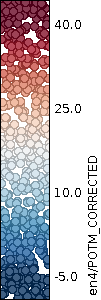
This example XML file displays in situ measurements of sea surface temperature a coloured glyphs.
<?xml version="1.0" encoding="ISO-8859-1"?>
<StyledLayerDescriptor version="1.1.0" xsi:schemaLocation="http://www.opengis.net/sld
StyledLayerDescriptor.xsd" xmlns="http://www.opengis.net/sld" xmlns:ogc="http://www.opengis.net/ogc" xmlns:se="http://www.opengis.net/se" xmlns:xlink="http://www.w3.org/1999/xlink" xmlns:xsi="http://www.w3.org/2001/XMLSchema-instance" xmlns:resc="http://www.resc.reading.ac.uk">
  <NamedLayer>
    <se:Name>en4/POTM_CORRECTED</se:Name>
    <UserStyle>
      <se:Name>Red-blue palette showing SST with basic glyphs</se:Name>
      <se:CoverageStyle>
        <se:Rule>
          <resc:ColoredGlyphSymbolizer>
            <se:Opacity>1.0</se:Opacity>
            <resc:IconName>circle</resc:IconName>
            <se:ColorMap>
              <resc:Segment fallbackValue="transparent">
                <se:LookupValue>Rasterdata</se:LookupValue>
                <resc:BelowMinValue>extend</resc:BelowMinValue>
                <resc:ValueList>
                  <se:Name>div-BuRd2</se:Name>
                </resc:ValueList>
                <resc:AboveMaxValue>extend</resc:AboveMaxValue>
                <resc:Range>
                  <resc:Minimum>-5.0</resc:Minimum>
                  <resc:Maximum>40.0</resc:Maximum>
                  <resc:Spacing>linear</resc:Spacing>
                </resc:Range>
                <resc:NumberOfSegments>250</resc:NumberOfSegments>
              </resc:Segment>
            </se:ColorMap>
          </resc:ColoredGlyphSymbolizer>
        </se:Rule>
      </se:CoverageStyle>
    </UserStyle>
  </NamedLayer>
</StyledLayerDescriptor>
The resulting output image and its legend are shown below: